The Florida USNG GIS Data Model website

Learn about the USNG GIS Data Model. Explore Features and Methodology.

In an effort to assist expediting the implementation of USNG throughout Florida and the United States, we are sharing the information from the About page on the http://usng-gis.org/index.html website below.

The USNG-GIS.ORG: Mission

GIS offices around the state are grappling with similar mapping challenges such as irregular and changing geographic areas, complex visualizations, data archival, and privacy concerns. Many of Florida’s cities and counties duplicate work efforts regarding demographics and census data.

Our goal is to assist Florida state and local governments in their GIS work by demonstrating the advantages of the United States National Grid (USNG) GIS Data Model. This model allows for high-resolution data of all types, improved visualizations, improved analysis, and easy data transfer between agencies.

Our mission is to provide a platform to assist Florida government agencies in their GIS duties. We demonstrate a GIS data structure that works at multiple scales. We provide starter datasets of basic population data, land use, and land cover so that GIS practitioners can begin testing these ideas for themselves.

usng-gis.org-lulc1-background-image

3RD annual meeting about USNG implementation nationwide – Daytona Beach – Florida Fire Chiefs Association

FLORIDA FIRE CHIEFS ASSOCIATION presents:  Fire-Rescue East 2017

When: Wed Jan 18, 2017 2:30pm – 4:30pm (EST)
Where: Fire Rescue East / Ocean Center
101 North Atlantic Avenue
Daytona Beach, FL {17R MN 9891 3328} + telecon
3RD annual meeting about USNG implementation nationwide; not a training class. Room M01D of Ocean Center. Attendance is FREE to any meeting regardless of all references to conference costs, etc.

Read More…

USNG is Saving Lives & helping to Find the Injured – booth at NASA Innovation Expo 2016

blog post

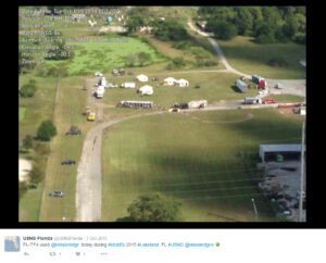
Florida Task Force 4 (FL-TF4) Joint USAR Exercise Incorporates U.S. National Grid and Mission Manager Incident Command Software for Team Coordination, Live Tracking and Situational Awareness in Lakeland , Florida

Urban-Search-n-Rescue-Team-Florida-TF4-Lakeland-2How does your hometown or local area deal with and respond to a natural disaster?  Who coordinates what, and what is the depth and scope of their planning ,coordination and implementation?

AND HOW DO THEY TRACK AND MAP ALL PEOPLE AND BUILDINGS WHEN ALL ROAD SIGNS ARE DESTROYED?

Here is an excerpt from the story at MissionManager.com to explain this training:
Read More…

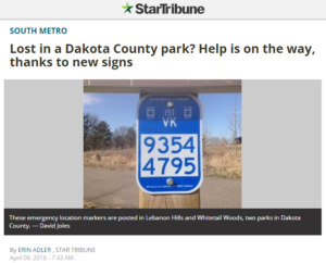
Lost in a Dakota County park? Help is on the way, thanks to new signs.

Here is a story of a rider and a horse that were saved in a Dakota County Park in Minnesota, because of those blue USNG signs.

Here is an excerpt from the story with a link to the rest of the article:

Dakota-County-Park-Signs-with-USNG-MarkersIt wasn’t a typical 911 call: last fall, a horseback rider wandered into Whitetail Woods Regional Park and became lost. Then his horse fell through a boardwalk and got stuck in the mud.

The caller reported his location using an eight-digit number found on a nearby trail post. First responders located him quickly and saved the horse, said Randy Knippel, geographic information system manager for Dakota County.

For Knippel, it’s a success story demonstrating the value of emergency location markers, a system he’s encouraged county parks to implement.

Read More…

Florida Fire Chief’s Association (FFCA) Position statement: US National Grid map updates and systems configuration

Florida Fire Chief’s Association (FFCA) Position statement: US National Grid map updates and systems configuration.  PDF article.Florida Fire Chief’s Association (FFCA) Position statement: US National Grid map updates and systems configuration.

See the article here:

Wildfire Aug 2014 Studt Lessons Yarnell Hill Fire

Wildfire-Aug-2014-Studt-Lessons-Yarnell-Hill.pdfArticle: Wildfire Aug 2014 Studt Lessons Yarnell Hill

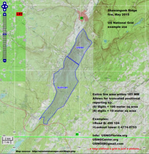
S-ridge-fire

About the Florida Today Hurricane Preparedness Map

Link to open the Florida Today Hurricane Preparedness map:
http://www.mappingsupport.com/p/gmap4.php?usng=17R_MM_9347_2639&tilt=off&z=9&t=m&q=http://usngflorida.org/files/gis-files/florida_today.txt

This map is displayed in your browser by Gmap4 which is an enhanced google map viewer. If you have not done so already, please take a moment and read the following “Tips” to learn how to:

  • Use your smartphone GPS feature to center the map at your location
  • See high resolution USGS topographic maps
  • Easily manage GIS overlay layers
  • Use the maps offline
  • And more….

 
Read More…

News-Blog

All News and Blog article Publishing will be found here, on the News-Blog page.

All new articles and updates that require their own page as a post, will go here.  And of course, there will be a list of the most recent posts in the right side column of all pages in the site, except home page.  This is similar to the page link I provide in the next sentence here, which is a list of recent posts displayed on many of the pages within the USNGCenter.org website,  in the right hand column.  http://usngcenter.org/portfolio-item/review-board/     Next up is development of the “Categories” for the database to make this website, as Useable and User Friendly as possible. Something we will want to do during the early stages of the site development.  This will make the site search feature an excellent tool for quickly searching recent articles, terms and archives.